Volcano Supersites are studied to learn how to reduce disaster risk
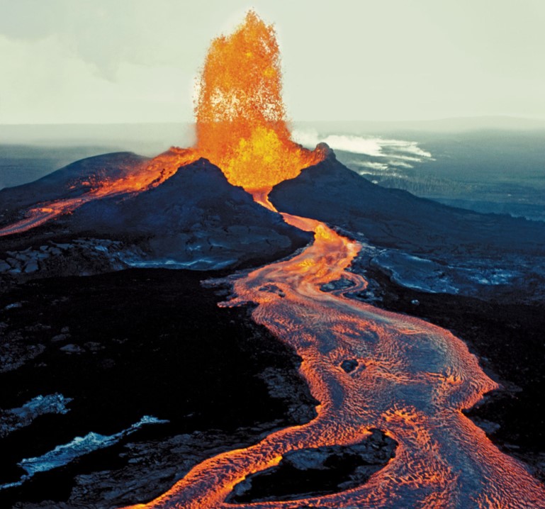
Volcanic eruptions are among the most spectacular and dangerous phenomena on Earth, capable of generating disasters of various scales. It is estimated that over 500 million people live within the exposure range of active volcanoes and can be affected by their activity. Mega-eruptions can cause global impacts on climate and human health, and induce considerable transnational economic damage. For instance, the eruption of the Icelandic Laki volcano in 1783 generated far-reaching ash and gas clouds which resulted in tens of thousands of victims across Europe. Today the toll would be in the millions.
The assessment and management of volcanic risk is thus a matter of global concern, which is constantly addressed at all levels. The first element to evaluate the risk is to develop a sound scientific understanding of the phenomena and processes which are part of volcanic activity. Then, to effectively manage the risk, the geophysical and geochemical parameters whose anomalies can signal an impending eruption must be constantly monitored. Thus volcanoes must be closely observed with a number of instrumental networks whose data should be rapidly analysed to provide early warning. Yet a study of 441 active volcanoes in 16 developing countries revealed that 384 have rudimentary or no ground monitoring, including 65 volcanoes identified as posing a high risk to large populations, such as the Nyragongo, in the Democratic Republic of Congo, where a city of 1 million people is located 10 km from the main crater.
A number of Earth Observation satellites is today available to support volcano monitoring, producing frequent measurements of surface and atmospheric parameters which are useful indicators of volcanic activity, such as ground temperature, gas concentrations, ground deformation, etc. The main space agencies of the world support Geohazard Supersites and Natural Laboratories, providing free access to thousands of satellite images, and local geophysical institutes make their seismic, geodetic, and other data open and available for the global scientific community. Complex algorithms are used to analyse these data and important information on the volcano activity. For instance, satellite-derived maps showing the millimetric movements of the ground are processed with complex geophysical algorithms which model the observed ground deformation patterns and help identify the depth and location of the magma sources. To investigate the characteristics of the Earth’s crust under the volcano and map its “plumbing system”, thousands of seismological recordings are studied using tomographic inversion codes. And when the eruption starts, the path of the large clouds of ash and gas which are emitted up to 12 km into the atmosphere, are constantly monitored and forecasted using dispersion models based on atmospheric and satellite observations. The impacts these clouds can have on civil aviation is tantamount: during the Eyafjallajökull eruption in 2010, over 100,000 commercial flights were grounded due to possible impacts on aeroplane’s engines functioning, causing over 5 billion Euros worth of economic damage.
All these analyses are based on complex geophysical inversion algorithms, through which a theoretical model based on a set of equations is calculated tens or hundreds of thousands of times, and compared with large datasets until the model which best reproduces the observations is found. Considerable computing resources are needed to run these models, and where the results are required for the management of a volcanic crisis, as for ash cloud mapping, these calculations must be carried out in a matter of minutes.
The computing needs of several volcano Supersites are now supported, for some processing applications, by the Poznan Supercomputing and Networking Center in Poland. Powerful virtual machines available on the Eagle supercomputer are provided for the Supersite scientific communities in Ecuador, Chile, Iceland, and Italy, who use them on a daily basis to unravel the behaviour of their volcanoes. It is foreseen that in the next decade, the requests for High Performance Computing resources will increase steadily.
Based on research carried out by over one hundred scientists in the GEO-Geohazard Supersites and Natural Laboratories initiative (geo-gsnl.org), chaired by Stefano Salvi, INGV – Istituto Nazionale di Geofisica e Vulcanologia, Italy in collaboration with Poznan Supercomputing and Networking Center, Poland.